Tuesday, November 28, 2006

Climate, Politics, Climbing on Mt Rainier in 2006

You better make the most of this cold snap and powdery snow if you're listening to the WA State Climatologists. They believe that the current trend of sub-freezing temperatures and record-setting precipitation doesn't mean much when discussing the long term forecast. They are still calling for a warmer, drier winter.

On to politics... Sixth District U.S. Congressman Norm Dicks discussed his view of global warming and Mt. Rainier in The Olympian. More importantly, he seems to have ponied up the $30 million dollars needed for estimated flood repairs:
"But everyone knows that the long laundry list of repairs,which the park estimates could run up to $30 million, will happen. 'We'll get the money in a supplement bill or in the 2007 budget,' said Rep. Dicks"
And a little climbing info... It's going to be really tough for anyone to ascend Mt. Rainier again in 2006, unless something miraculous happens fast. But speaking of money (30 dollars, not 30 million) one climber inquired about a 2006 climbing pass refund... We had to say sorry, there are no refunds, especially for this natural disaster.

Sunday, November 26, 2006

Heavy Snowfall

Sub-freezing temperatures and heavy snowfall dominate the mountain and complicate the flood recovery. Since Tuesday the 21st, over 77" of new snow has fallen at Paradise; as of Sunday the 26th, there was 71" on the ground (note the compaction). In Longmire, we measured 7" of new today for a total of 26" on the ground and it's still November! Winter has arrived, in full force.

I added a new blog, Flood Photos and More, to address the importance of the event and recovery. At this stage, I haven't been able to organize it, but in the next few days there will be more images and narratives. Stay tuned...

In the meantime, I appreciate your emails and thoughts. Sally Johnson sent this photo (taken last Fall) to say that she misses Paradise, especially during the first few snowstorms that blanket the meadows and trees. But Sally is not the only one lamenting the lack of access. A few of you have even posed some interesting questions in hopes (I think) of getting back on the mountain. So to be clear, we don't need backcountry skiers to test the snow stability near Paradise. Yes, I understand that ski-compacting fresh powder might reduce the avalanche hazard.

Thursday, November 23, 2006

Turducken

It was 28 degrees at Paradise yesterday (Wed) with 14 inches of powdery new snow. And after today's deluge and temperature drop, we can safely assume that AT LEAST another foot fell. With such snowfall, I'd normally be optimistic about our winter snowpack and climbing conditions. But for the next month (and it sounds like more) we'll probably have to get our climbing, skiing, and other winter thrills elsewhere. An article in the Seattle Times says that "In a "best scenario," the gate to Longmire will open by Christmas." Notably, there were no predictions about the road to Paradise being restored. Hummm...

So it's Thanksgiving... and I am quite thankful that the Nisqually River didn't wash my home away this year. I am also thankful for the turducken I ate. You know, a chicken stuffed inside a duck stuffed inside a turkey. It's de-boned and filled with all sorts of Cajun goodness and it tastes absolutely delicious! So why do I share this culinary tidbit? Because a turducken is something you can obtain right now. But if you wanted that powdery snow at Paradise, the snowpack reports might be torturous given the current access.

Happy Thanksgiving!

Friday, November 17, 2006

Political attention & during/after Mt Rainier's flood photos

Mt. Rainier is getting a lot of attention these days. On the political side of things, the new Director of the National Park Service, Mary Bomar, visited last week. She toured flood damaged areas firsthand and spoke with NPS personnel about the event, the progress and the longterm difficulties. And today, U.S. Representative Norm Dicks followed suit. The Congressman also visited many of the damaged areas, and like Mary, wanted to get a better sense of what it was going to take to get Mt Rainier National Park reopened.

This flood/rain/storm event has made evident the challenges of managing facilities and roads in the shadow of a major glaciated peak that is slowly loosing its glaciers. Kautz Creek is quickly becoming the poster child of how Mt. Rainier National Park will manage this complex situation. As it stands now, Kautz Creek continues to flow over the Nisqually to Longmire road because it jumped its main channel upstream in an area that is legally designated "wilderness." The hard question is, how do you provide safe, reliable, and financially feasible road access through a threatened drainage that is known for glacial outbursts and episodic floods? The photo above displays the culprit, Kautz Creek, shortly before it enters unchartered forest as it forms a new channel. This picture was taken roughly one mile upstream from where the creek now intersects the main road.

And speaking of photos... Here is another set of "during and after" pictures of Mt. Rainier's flooding. This set focuses on the Nisqually River bridge near Longmire, seen here on Nov. 6th.


Compare this to roughly the same image today, an obvious contrast to the muddy storm flow above.

On the media side of things, the News Tribune digressed from the storm damage coverage to tell us how high Mt. Rainier is, EXACTLY! Who'd have guessed how complicated this answer was?

Heavy equipment and during/after photos

The road to Mt Rainier National Park's recovery is passing through some interesting terrain. Today, I saw a large bulldozer working in the Nisqually River. One of the vexing problems for the NPS is that rivers and streams have jumped their main channels. During a storm, riverbeds can become filled with debris, which in turn causes the river's flow to change its course. To some extent, that is why the Emergency Operations Center was threatened, and why the stream jump at Kautz Creek is causing such a repair headache. So to protect the facilities in Longmire, heavy equipment is now being used to clear the build up of rock, logs and other debris from the last rainstorm and flood.

The historian in me wanted to capture a during and after view of the Nisqually River. Here is the "during" image from Monday afternoon, Nov. 6th when things really started to roll. This picture is taken from the Longmire bridge looking upstream.


And here is the "after" view, taken today Nov 17th. Note the tree that hangs over the Nisqually River in both photos, and also the color of the river.

Wednesday, November 15, 2006

Mt Rainier Storm & Flood Damage Photos - Carbon/Ipsut

The NW corner of the park usually has its own share of flood related damage each year. And though it's not unusual for there to be Carbon River inspired washouts, this rainstorm brought substantially more destruction to the area. For example, here is the idyllic Ipsut Creek Cabin. It suffered heavily during the flood. Is it me, or does this place remind you of Yoda's house on Dagoba?

This creek diversion gives literal meaning to the name, Ipsut Creek Cabin. If Yoda did live here, he'd have to use quite a bit of "the force" to fix things.


As for the Carbon River Road, more than two miles of it washed away in at least four separate spots. In some places, the river flowed down the middle of the road (like here). For climbers, this could spell delay in early season attempts of Liberty Ridge.


AND another washout closer to Ipsut Creek Campground.


As for the Wonderland and other park trails, here's a brief run down on the storm damage. Keep in mind, the full extent may not be known till next spring, as these assessments were made from the air. For now, backpackers should probably expect things (bridges) to open up later than normal next summer. There are at least 10 bridges out around the Wonderland Trail. New trail needs to constructed in four other places. That includes a half mile reroute between Lake James and Cataract Creek and another 750 foot section in Stevens Canyon. NPS Photos

Tuesday, November 14, 2006

Mt Rainier storm & flood damage photos - Ohanapecosh

Snow is accumulating at Paradise. I measured 46" total, with 15" of fresh snow this morning. It looks and feels like winter and if the park were open, skiers, boarders and snowshoers would be enjoying the early snowfall. But the floods really did a number on the roads and as the days pass, it becomes more clear how complicated the damage is, especially with the prompt arrival of winter.

Since it's going to be difficult to write about the climbing routes and upper mountain while the park is closed, I will devote more energy to the events surrounding the park being reopened. There will be updates, damage assessments, projected repairs and ongoing weather observations. I'll also pull together photos, when possible, like these NPS pictures of the Ohanapecosh area.

Above left is an interpretive sign in the Grove of the Patriarchs that has been flooded with mud and silt. Normally, this type of sign rests about 3 and 1/2 feet above ground.

The heavy rain also lead to a number of landslides, like this large one near Ohanapecosh Campground. The slide started on the road above (out of image) and swept everything in its path down to the Ohanapecosh River and Campground.

Here is the primary deposition zone for all of the timber that was unearthed in the same landslide.


The river also moved and in doing so, took a couple of the campsites with it. Here is the new loop C of Ohana.

Saturday, November 11, 2006

SNOW... and more flood damage photos

In the newspapers, NPS officials predict road openings as late as Christmas, but cautiously hope it will happen sooner. At this time, it's difficult to tell just how long it will take to get things ready. Another complication is the ongoing Paradise construction project. The contractors had planned to work continuously this Fall and this isn't helping. In the meantime, I'm cheering for the road, electric and water treatment crews who are hustling to get things reopened.

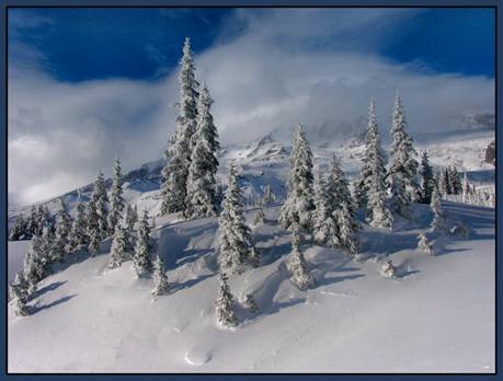
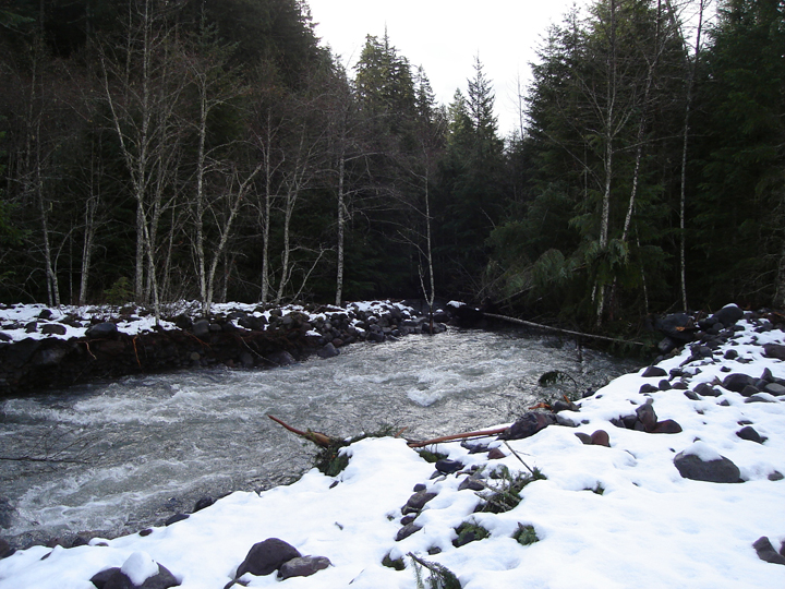
It snowed in Longmire Friday night. It was only a few inches, but enough to ignite those enthusiastic dreams of pristine mountaineering and great backcountry runs. Paradise measured 18 inches of new snow Saturday and 21 more today, Sunday! The National Weather Service is calling for another
storm, which has already started off colder.

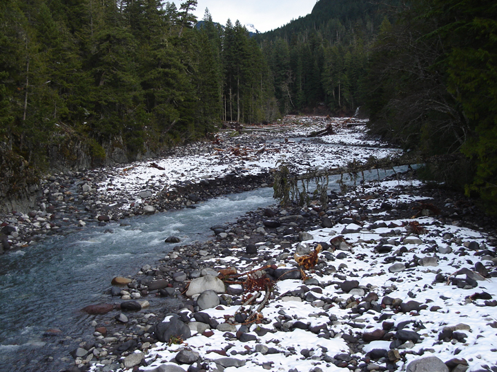
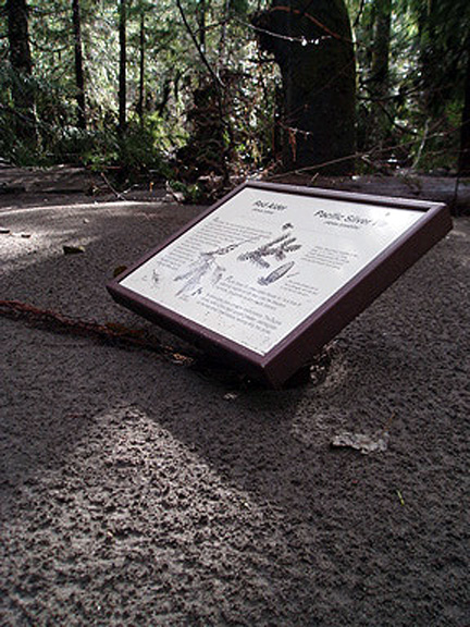
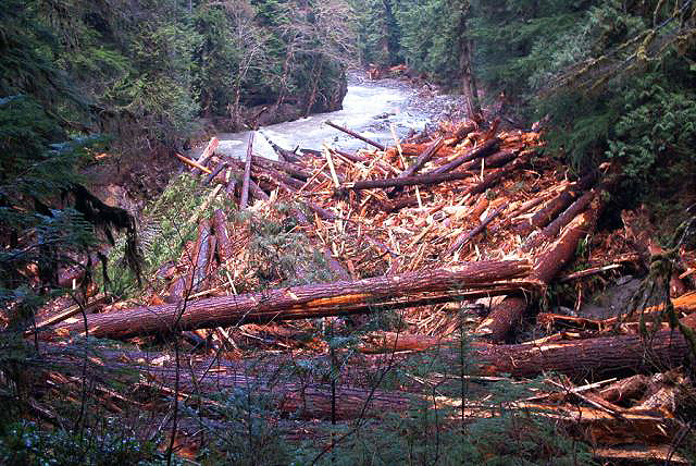
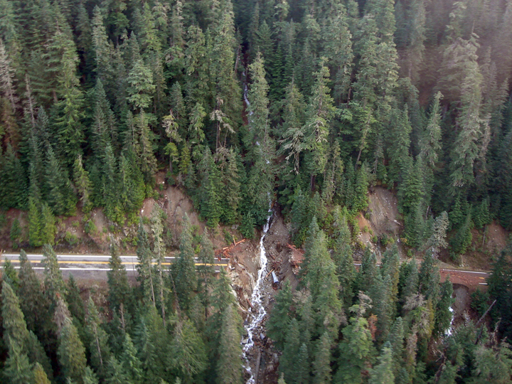
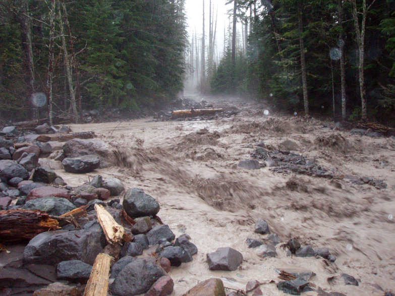
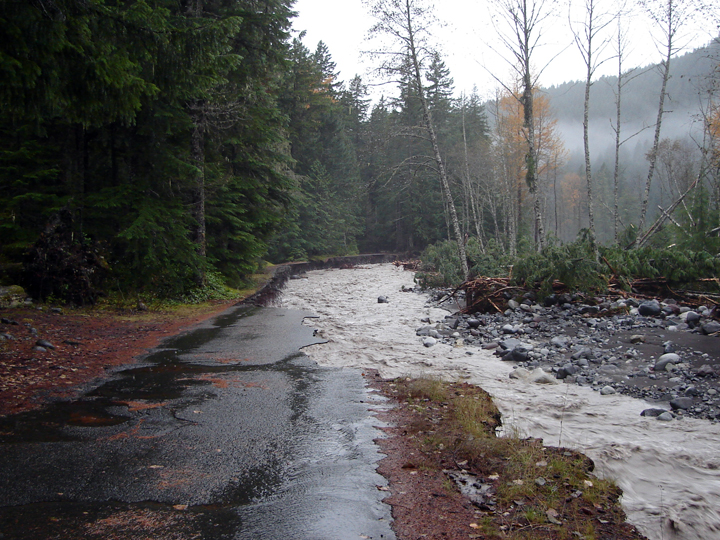
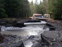
Here are a few extra images that I didn't weave into the blog earlier. To the left is the only road into the Kautz Helibase. This one may not be so easy to repair, because some of the creeks have changed their course and now flow down road corridors.

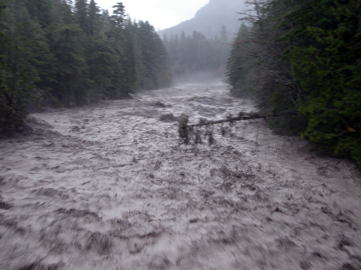
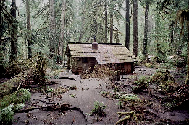
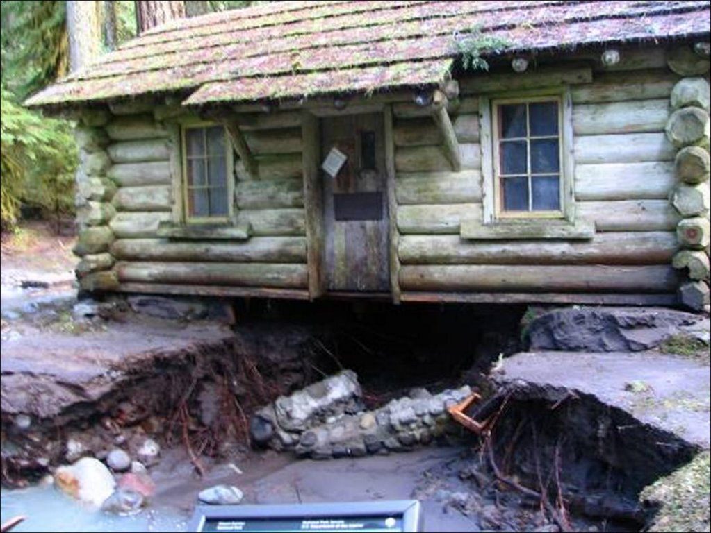
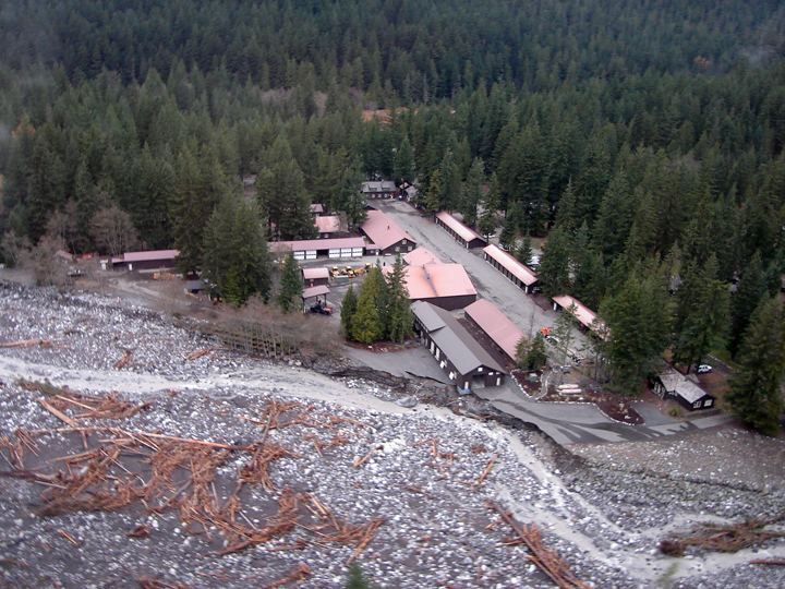
The main image above is of Longmire from the air. You can note that the river's flow has decreased, that there are a number of recently uprooted large trees and new log jams, and that the river came very close to taking out the Emergency Operations Center.

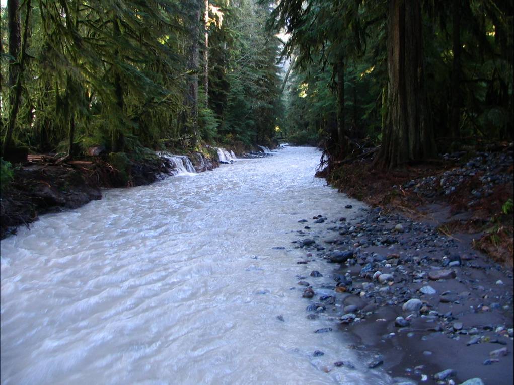
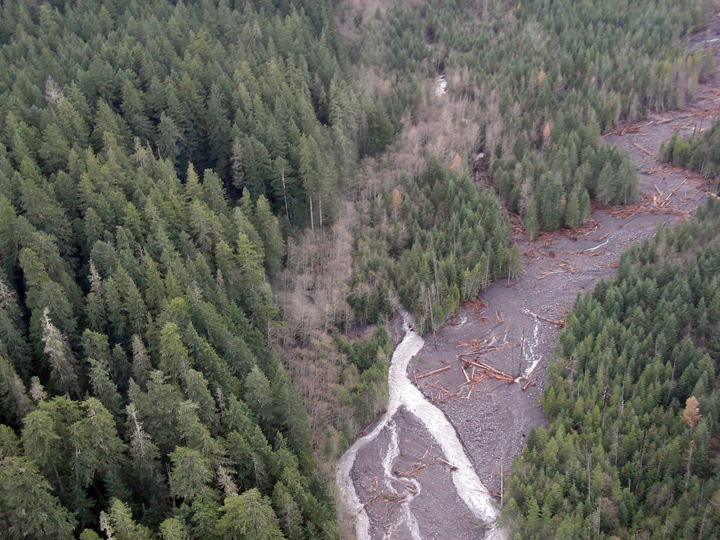
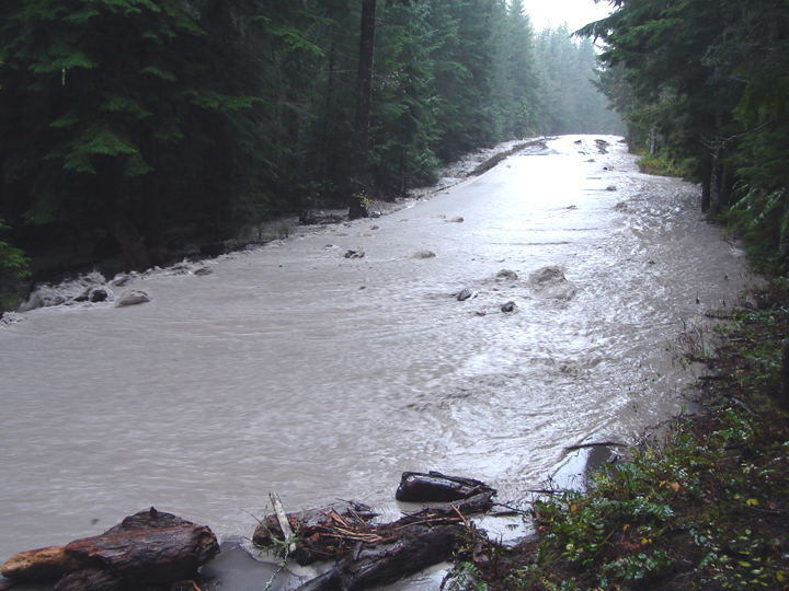
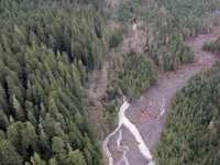
As for creeks that change their courses, the main one of concern so far is Kautz Creek. It jumped its main channel about a mile above the road, and now runs through the forest as seen in this aerial photo. Note the dry creek bed where it once flowed. You can also see the younger forest as compared to the older growth.

Friday, November 10, 2006

A mountain of maintenance

I've been wondering about the upper mountain. It must be snowing up there today, because the temperatures are much cooler here in Longmire. The Camp Muir and Paradise weather stations are both offline... Perhaps they are casualties of the intermittent disruption of power, phone and internet. I do know this: there was 7 inches of snow on the ground at Paradise yesterday, and I can see a snowline at 3,500 feet today.

I am also wondering about all that rain on the glacier. I have a feeling that at some elevations, the rain turned the glacier into hard/bulletproof ice when the temperature dropped. Here is the Nisqually Glacier from the air, taken on Wednesday.

It has been raining steadily today, but the river flow and currents have remained normal. Access to the backcountry and mountain is dependent upon repairing the park's infrastructure. A lot of cranes, dozers, and dump trucks will be needed to re-sculpt the land for roads and sewer systems. Like today, I saw a large crane moving rock in the Nisqually River in order to help protect a historic cabin, road and treatment plant. But it's not everyday you see this sort of thing in a national park.

There was another spate of articles online at MSNBC and in the local papers about the park closure and flood damage. The big pieces were in the News Tribune, Seattle Times and the
Yakima Herald. In the meantime, let there be colder temps and stable weather.

Wednesday, November 8, 2006

Regaining ground in the park, the NPS makes its move

The skies parted for a while today and the mountain finally revealed itself. Plastered ice and snow coated the upper 3-4,000 feet, seen here from a recently improved view point near Kautz Creek. Everything below 9-10,000 feet appeared thin and icy, i.e. very little winter snowpack, see below. Rumor has it, another storm is on the way. I hope it brings colder temps.

I snapped this image late today before the clouds returned. That is the Nisqually Glacier on Mt Rainier, the trails of the Paradise area in the foreground. The glacier ice looked really blue after the intense rain, and the mountain looked awesome.

For 24 hours, this was a place that people simply left. Today, the NPS resummed its plan to restore facilities and order to the park after 18 inches of rain fell at Paradise in 36 hours. The level of the primary rivers and tributaries remains high and it's very easy to note the newly scoured banks and freshly deposited log jams along the river corridors.


There was a noticeable change to the silence as the restoration effort moved forward. Electricians, water treatment specialists, and heavy equipment operators returned to Longmire and other parts of the park to assess the damage and begin the repairs. Highway 410 will open soon (probably Thursday) but the Carbon River road, Highway 123 and the Nisqually to Paradise road will remain closed (probably for a few weeks).

We surveyed the storm damage from the air this afternoon. The main hits were taken at Sunshine Point, Stevens Canyon (in somewhat predictable locations, see photo above-left) and on Highway 123 (left) where the road washed out entirely. The damage to Highway 123 looked severe given the time of year; I wonder if it won't be fully sorted out until 2007. At the Sunshine Point washout, I saw earth movers in the remains of the campground (now river bed). They were trying to make things happen for the road to Longmire, but the job seemed large because the road was entirely gone.

The sound of silence approaches, as soon the generators will be turned off for the evening.

Tuesday, November 7, 2006

Power: Nature turned Generator

The rain seems to have stopped and now you can hear the Longmire generators (6-10 am and 4-8 pm that is). It's going to take some time to put things back in order, but it seems as though the main brunt of the storm and its damage have subsided.

Sunshine Point Campground near the Nisqually Entrance was disappointed with the weather trend and left Mt. Rainier National Park for sunnier locations. The problem is that it took the main road with it. I couldn't get a visual though because the road near Kautz Creek was under 3 feet of silty debris and water. The creek must have diverted upstream and chosen a new channel. See photo above.

If you're familiar with the park, you'll notice a number of "new viewing areas" along the Nisqually to Paradise corridor next time you visit. The Nisqually River ran bank to bank and in doing so, took a massive amount of debris with it. Large trees fell, as new embankments were chiseled.

Here is another image of the westside road. See it? Neither do I. Well, 8 pm is approaching...

Evacuation and Damage

The Park remains closed until further notice. For updated information, call 360 569 2211 ext 9.

The onslaught of rain continued throughout the night. The Paradise telemetry recorded another 7 inches, bringing the total to 18 inches of precip over the course of the storm... and it's still raining!

Aside from the rage of the Nisqually River, Longmire is a relatively quiet place. The NPS has closed its offices, and only essential personnel are allowed in through a backroad (which is largely washed out and requires shuttles). See image above, taken near the Eagle Peak Trailhead...

The flooding has seriously damaged or threatened many of the roads (and even a few of the facilities) in the park. This image was also taken from the Longmire backroad below the Community Building. You can see where the road once existed.

Longmire is isolated by washouts and mudflows, so it feels like a safe little island. Well, "safe" unless you're in the Emergency Operations Center (pictured left) which is being undermined by the Nisqually River... Oh, and some of the electrical and water systems are also damaged, but most of the facilities will probably survive the storm.


I'll provide updates when possible. If you plan on visiting this side of the park anytime soon, consider that it's going to take a few days to repair the main road between the Nisqually Entrance and Longmire. I hear that it's completely washed out near Sunshine Point Campground. And speaking of that campground, it's GONE.

Monday, November 6, 2006

No, it's REALLY raining up here

The southside of the park is closed; the rain has started to wash out or significantly threaten a number of roads and access points. For updated information about weather and access, call 360 569 2211 and press ext 9.

Updates: the weather observations for Paradise measured 11.3 inches in the past 24 hours! At Camp Muir, the temps hovered in the mid 30's (probably rain) but it was the wind speed that remained impressive. Gusts of 121 MPH were recorded and the average wind speed for one hour in midday was 101!! The Nisqually River (pictured right) is nothing short of a boiling chocolately torrent, as is every other creek and stream around here. The river sounds like a freight train and the ground trembles as large boulders and old-growth trees jostle into the flow. The air even smells of glacial mud, cedar and pine.

As it stands now, the NPS is evacuating any non-essential personnel from the park before the roads completely wash out. The Carbon River road is also closed, as is the rest of the park.

Hard Rain

It rained 7 inches in the past 19 hours at Paradise. We are hoping for snow, but the possibility seems remote. The Camp Muir telemetry says that it's been above 32 F since mid day Sunday. Interestingly, there was no wind measured while below 32 F, however once the temp stabilized above 34 F, the anemometer proudly reported gusts up to 118 MPH!! Zero-118 in one hour... maybe the equipment froze? Regardless, Camp Muir is probably a miserable place to be right now.

More soon...