I continue to get questions about the best way to access the mountain (i.e. Paradise). For all practical purposes, getting to Paradise is almost impossible. Why? Because there is NO public access allowed along the road corridor above Longmire. That means if you have a trip to Paradise planned for later this winter or early spring, scale back your access expectations and consider other locations.
 Access to White River isn't that bad, if you have a snow machine. One party rode into the campground, parked, and then snowshoed up to the Inter Glacier. To the right, a snowboarder breaks trail through Glacier Basin (image by Don Boutry). Perhaps some climbers will follow suit? And while we're discussing access to White River and Sunrise... the current thought is that the projected road openings will go as planned next spring. This is welcome news considering the delayed openings on HWY 123; it was totally severed and may not be fully repaired and re-opened until next fall!
 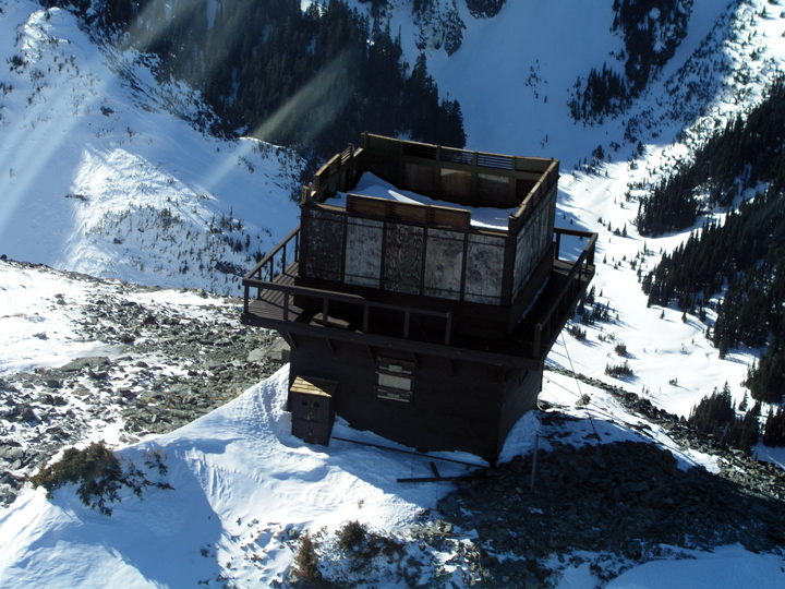 Last week, NPS rangers discovered more facility damage to a few of the fire lookouts. Here is Fremont Lookout from the air. Note that the roof is missing. Similar damage was found at Gobblers Knob (the roof blew off and a wall collasped) but Tolmie and Shriner (the other lookouts in the park) survived OK.
The current talk points to an April 1st road re-opening to Longmire. That would make access to the Westside Road easier and more reliable. As for Paradise, they are cautiously predicting May 1st...
 As for repairs, they just paved the road at Sunshine Point. Meanwhile, the road crew is installing more culverts at Kautz Creek. Another engineering obstacle remains at milepost 5, where the uphill lane is slumping towards the river. It may not look like much in this photo, but the embankment below is severely eroded by the Nisqually River.
 You may have noticed that I am now managing the photos on Flickr and have finally started posting images in the flood folder. But using blogger for this purpose isn't that easy, so we'll see how much I can do with it...
No comments:
Post a Comment